 |
| The Hinterbrand fall shaded and tucked into a narrow gully |
The Hinterbrand ice fall runs down from under the Hinterbrandkopf (Berchtesgadener Alpin, Hoch Kalter range) in a south-west direction. On the Bayern Landesamt map (Lattengebirge, Reiteralpe - BY20), the thin blue line is visible embedded in a gully topping out at around 1500 meters.
 |
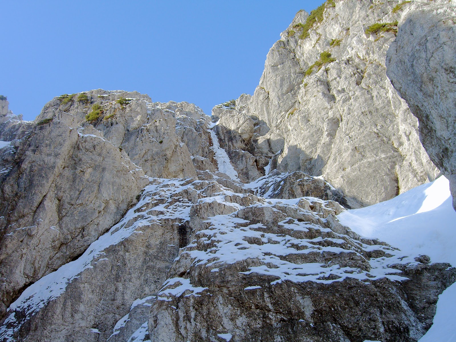
| Snow approach coulior to first ice ramp |
After a short training break to allow some injuries to heal, I went back into the Wimbach drainage to hopefully find something interesting to climb. I have lots of projects in the area -- ice and winter alpine climbs as well as ski descents. It is just a matter of searching and then waiting for the right conditions.
I had seen some potential ice lines last October and November on the west flanks of the walls under the Hoch Kalter, Ofentalhörndl, Steintalhörndl and Hinterbrandkopf.
 |
| First pitch: snow cone to ice ramp leading to mixed ground |
 |
| Mixed ground leading to upper ice fall |
On Tuesday, 15 February, it was clear and cold in the morning hours. I did the 3 plus hour approach to the climb in my mountain boots and short skis. Skiing with mountain boots and approach skis is a skill that I want to improve upon. It is an essential skill for winter alpine climbing and getting to secluded ice climbs.
I skinned up to the steep snow before the actual ice and got all my gear ready. I brought a very small amount of ice and rock protection and two small diameter 30 meter ropes. I planned to free solo as much as possible and use the equipment for getting down.
 |
| In better conditions, this would all be ice |
I could free solo the first 20 meter ice ramp that led to mixed ground. Water was already running down the exposed rock as the sun warmed up the upper face. The ice quality was not that good. The ice had melted away from the rock underneath and then refroze so that the ice was not bonded to the rock.
The mixed climbing was insecure -- snow over loose rock at times running with water. The rock in this area is very friable and not to trust. It is also at times difficult to put in rock protection. Before climbing the mixed ground, I built a large ice/snow bollard as a main anchor. I self-belayed over the mixed part, traversing right to solid snow that would lead up and leftwards to just under the main ice.
The upper ice fall was not as steep as it looked from below. However, the ice quality was not that great. I carefully climbed the last 30 meters or so of ice free solo. I would say it was WI3+ or so.
The climb then starts out with a short bit of steep snow followed by an ice ramp (WI3) going from left to right. Then comes mixed ground ( in better conditions it will all be ice) to the snow under the main ice flow. The last 30 meters of ice is split in two sections, with a clear step in the middle.
 |
| Looking down from the top at the first rappel |
At the top I built a good V-Thread and rappelled down to the snow under the steep ice. Two further rappels brought me down to the snow couloir which I down climbed to my skis.
There was a hard base of snow covered at first with a dusting of powder. As I lost altitude, the snow surface softened up to a couple centimeters of corn. As long as the snow was not tracked and rutted, the skiing was fun.
 |
| Second rappel over mixed ground |
 |
| Last rappel |
I have never heard of anyone climbing ice back in the Wimbach drainage. There is certainly no information about this climb. I believe that it is a first ascent, but who knows for sure? It was definitely a first ascent for me! Hinterbrand Ice Fall 80m, WI3+ & easy mixed.
No comments:
Post a Comment